The Lumbering Elephant
Signs that the Elephant and Castle Shopping Centre might not be as successful as was thought initially were confirmed early. With just nine months left till completion only half of the shops had been let or had attracted interest.72 When it opened in 1965, just twenty nine out of a possible 120 shops were trading.73
The scheme had been launched with great optimism. Sir Isaac Hayward, leader of the LCC in 1956 addressed the Council with confidence:
By imaginative and realistic planning and with goodwill and co-operation between the council and business and trading interests the Elephant and Castle, I am sure, can become one of the main commercial, shopping and entertainment centres of London. With its famous name, history and tradition on which to build, the new Elephant and Castle offers opportunities one would have to go a long way to better. Here's a real chance to 'show them how' on the north side of the Thames.74
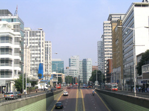
The LCC had told developers that the new centre ought to contain 290,000 square feet of space with a minimum of 100,000 for retail and the rest given over to offices. These huge figures were made with no analysis of the market demand for such space. They were completely exaggerated and revealed the 'fatal amateurism of the project.'75 The volume of the original 36 entries to the competition appeared to confirm to the LCC that the location was right. The LCC trusted the market and the market trusted the LCC's figures. The winners of the competition, Willets, had never built shops before. In their sales brochure of 1963 they made ludicrous claims on the adjacent catchment area, which revealed no viability study or basic market research. Within a three mile radius of the centre, they claimed there were a million people who would use the centre.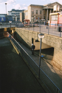 Figure 5476 This ignored local alternatives and staggeringly assumed people in Westminster would choose the Elephant over the West End. It also cited the 42,000 vehicles that passed through the Elephant daily, the 50,000 people using the Northern and Bakerloo lines, the 68,000 people using Blackfriars Station and the 400,000 at Waterloo and London Bridge as potential visitors.77 It also envisaged a growing working population at the Elephant itself of over 15,000. These figures ignore the fact that the Elephant tends to lie on the route of people whose destination is elsewhere. Abercrombie deemed the area a gateway: it may be something at which you are forced to stop, but it is primarily something you pass through.78
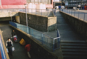 Figure 55Willetts and the LCC had not taken into consideration the shifting population demands. There had been a twenty-five year gap between the dropping of the first bombs and completion. South London is full of adjacent high streets that provided comparable services. People had simply moved elsewhere to shop. The shopping centre site, bounded by fast moving traffic and a tortuous network of subways as the only means of access also contributed to its failure (see figs 54 & 55). People could not conveniently get to it and its inward facing layout did not advertise itself to passers by; the architects themselves admitted 'the site is really saying no with a big NO to almost any poor pedestrian who wants to creep into the building.'79 Traffic had isolated each site and the subways contributed to the misery.
The Elephant had never attracted the frenzied commercial attention that coloured the early years of the office boom elsewhere. It was dominated by public sector investment - a process described by one commentator as 'priming the pumps.'80 The shopping centre was saved by the successful letting of the office space at Hannibal House, "the safety valve," to the Ministry of Works, "the developer's friend."81Alexander Fleming House was completely let to the Ministry of Health. Following the opening of the shopping centre, development was sluggish.
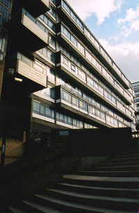 Figure 56
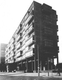 Figure 57In the early 1970's the new Greater London Council (GLC) completed Perronet House at Site 4 (see figs 56 & 57). The original plan for the site was for retail, but the public sector wanted a mixed development with housing. Developers showed no interest in this if they could not include offices, as retail had already proved problematic. The Council pressed ahead with its own block, which became a commercial disaster. The block was architecturally confused and owed something to the influence of the Buchanan Report. Its residential mass mimicked the geometry of Alexander Fleming House across the roundabout, but the retail turned its back on the scheme and was put at the first floor. Raised on a podium above a car park, it was completely invisible to all but the few residents in the block. No shop was let. Tim Richardson, in his 1979 analysis of the redevelopment for the Architectural Association summed up the farcical situation:
The building is not designed in any relationship to its function or its users or its location, it is designed to complement an office building so far away that it is physically impossible to see both at the same time and marvel at their similarity.82 In 1972 the Department of the Environment unveiled plans for a large scale tower at Site 3 at the northern end of the scheme in accordance with plans now nearly twenty years old (see fig 58). The necessity of the tower was well recognised. It "would be a beacon... the distant view a South London tour-de-force."83 It never materialised and the site remained derelict for years. In the same year the Architects' Journal dubbed the Elephant and Castle a "write off."84 In 1978 a Recreational Centre was finally provided by Southwark Borough Council (see map fig 29). By this time the Elephant appeared increasingly symptomatic of wider failings of the inner city and a faltering public sector. These factors were to be crucial in the future development of London.
In 1969, as a major part of its Greater London Development Plan, the GLC had confidently unveiled its system of ringways. In its accompanying publication it declared, "if London comes to a standstill, or even slows down to a permanent crawl, planning has failed."85 The roadways were yet another overdue revival of the 1943 plans and were hugely ambitious (see fig 59). The estimated cost was to be 2 billion and work would involve the demolition of approximately 20,000 houses.86 Almost as soon as the plans were published they sparked controversy which, combined with parallel events elsewhere in the city, raised questions as to the wisdom of central planning control and the post-war consensus. In the reform of London government in 1965 the GLC had acquired control over its own roads. In the years following, roads would cease to be a purely technical issue commanding cross party support and become politically devisive.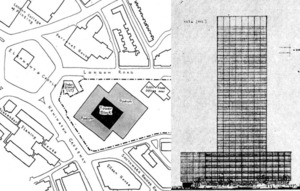 Figure 58
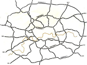 Figure 59
The 1969 Development Plan received 22,000 objections87 and in 1970 a public inquiry was launched into its implementation. In the same year a glimpse of the future could be had with the opening of the Westway. For motorists, it provided a stunning new panorama from which to experience the city at speed. However, for residents nearby, the elevated motorway demonstrated the negative impact of the car. The road divided the community of North Kensington in two and blighted surrounding areas with its noise, pollution and visual intrusion. It was the source of huge public demonstrations that gained the support of the Evening Standard88, who brought to a wider audience the scale of what coming to terms with the car really meant. The growing resentment was seized upon by political parties. In 1970, GLC candidates stood supporting a call for "Homes Before Roads."89 In 1971, the Labour Party in London came out against the ringways plan, only a few years after having been instrumental in their devising, and in 1973 overwhelmingly won control of the Council on a "Stop the Motorways" pledge. The ringways had been dropped and it seemed the motorway age and the car-owning democracy would not materialise in London. Change elsewhere also proved difficult to manage.
There had long been held the belief that planning was in the public good. The ringways issue highlighted a growing distrust of planners and their ability to provide what was best in the interests of the public. These thoughts had been cemented much earlier in an American publication of 1961. The Death and Life of Great American Cities, by Jane Jacobs, mounted a scathing attack on city planning and rebuilding, and criticised planners and architects for trying to apply a grand visual order at the expense of a diverse public arena:
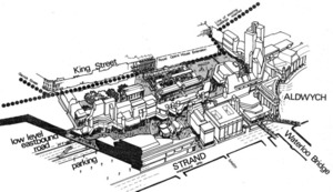 Figure 60To approach a city or even a city neighbourhood as if it were a larger architectural problem, capable of being given order by converting it into a disciplined work of art, is to make the mistake of attempting to substitute art for life.90The disillusionment with the results of planning from above was turning against other aspects of the 1969 Development Plan. The comprehensive redevelopment of Covent Garden Market ran parallel to the events concerning roads and received similar condemnation. The plan, dating from 1965 and covering 96 acres,91 proposed large scale demolition of largely 18th and 19th century buildings around the historic market building for replacement with a multilevel complex of hotels, conference facilities, access roads, shopping malls and offices (see fig 60) . At its 1971 inquiry it was opposed by everyone and a revised scheme influenced by conservation concerns was produced in 1976.92 It challenged the prevailing ethos of modern architecture and the "bulldozer approach," as a source for good in the public realm and brought attention to the preservation of the past and traditional forms. Such tendencies towards conservation, cast doubt on the ability of schemes such as the Elephant and Castle to succed in providing a desirable environment in future. Its architectural forms became part of a language of popular misgivings of centralised control.
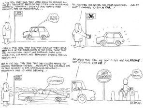
The post-war consensus of modernising London through redevelopment and traffic circulation appeared to be falling apart during the 1970's. It was a period of great flux and the city was displaying symptoms of fragmentation through the pursuit of earlier planning goals, which had begun to show their failings (see fig 61A).
Between 1939 and 1977, Greater London lost approximately 1.5 million people through policies of decentralisation and dispersal.93 Abercrombie's recommendations had simply worked too well without government realising the damaging impact of such large movements. In 1951, the Inner London population had been 3.3 million, by 1976 it was 2.4 million; about half that of 1901.94 People were encouraged to move out of the city to seek better lives, more open space and better housing beyond the greenbelt in the New Towns or elsewhere. The result was a slow decline in the fortunes of the inner city. Traditional economic activity stagnated at a time when the Docks were closing in large numbers and an economic slump severely reduced the breadth of the public sector's ability to support regeneration. Communities were broken up and only the very poor or newly arrived remained. As people moved out, industry followed and, as it grew, pulled skilled labour out of the city. Between 1959 and 1974, London lost 38% of its manufacturing output. Inner London alone lost 41% of its manufacturing jobs.95
In the early 1960s, as discussed, the levels of road congestion were critical during the period of the office boom. In 1945, there had been 78 million square feet of offices in the central area; by 1966 there was estimated to be 178 million.96 To lessen the pressure on central London roads, a government ban of 1964, initiated by Labour Minister of Economic Affairs George Brown97, was put on large scale office construction in the central area. The result of the 'Brown Ban' was a gradual move of clerical work to the suburbs and the growth of suburban centres such as Croydon, which threatened the traditional dominance of the centre (see fig 61B). Central government aided this movement through the establishment of the 'Location of Offices Bureau.' A poster campaign of 1977 read: "Move out, before London costs strangle your business."98The effect of such policies was that while central London was constrained by congestion, there emerged the formation of a 'Ring City' around the edge that benefited from good roads and cheap land. It was here, in the suburbs, that the future of the motorised city would find prosperity. At the same time as job opportunities were exported to the periphery, the inner city at the Elephant and Castle was increasingly overlooked, its role unclear.
Footnotes
- ↑ Marriott, 1967. p.218.
- ↑ Richardson, T, 1979. 461.3.
- ↑ ibid.
- ↑ Marriott, 1967. p.216.
- ↑ Willetts Sales Brochure, 1963. p.9.
- ↑ Willetts Sales Brochure, 1963. p.10.
- ↑ Bendixson, Terence, 1967. p.281.
- ↑ Marriott, 1967. p.220.
- ↑ Bendixson, Terence, 1967. p.281.
- ↑ Marriott, 1967. p.215.
- ↑ Richardson, Tim, 1979. 481.7.
- ↑ Bendixson, Terence, 1967. p.285.
- ↑ The Architects' Journal, October 18th, 1972. p.868.
- ↑ GLC, Tomorrow's London: A background to the Greater London Development Plan,1969. p.62.
- ↑ Hamer, Mick, 1987. p.59.
- ↑ Ibid. p.59.
- ↑ Starkie, David, The Motorway Age, 1982. p.77.
- ↑ Ibid. p.61.
- ↑ Jacobs, Jane, The Death and life of Great American Cities (Fifth edition), 1984. p.386.
- ↑ Hall, Peter, Cities of Tomorrow (Third Edition), 2002. p.287.
- ↑ Ibid.
- ↑ Wilcox, David & Richards, David, London: The Heartless City, 1977. p.7.
- ↑ Ibid. Population decline by 25%. 1901 figure 2.35 million. Taken from White, Jerry, 2002. p.73.
- ↑ White, Jerry, 2002. p.207.
- ↑ Ibid. p.52.
- ↑ George Brown headed Labour's Department of Economic Affairs in 1964.
- ↑ White, Jerry, 2001. p.52.
